
Carbon Dynamics Project Overview
Principle
Investigators
Stephen Roxburgh (ANU, CRCGA)
Brendan Mackey (ANU, CRCGA)
Chris Dean (formerly CRCGA)
Jenet Austin (formerly BRS/CRCGA, now CSIRO)
Lucy Randall (BRS, CRCGA)
Alex Lee (ANU, CRCGA)
John Gallant (CSIRO)
Richard Lucas (UWA)
Introduction
The Carbon Dynamics project was initiated in 2002 as part of the CRC for Greenhouse Accounting (CRCGA) collaborative initiative to promote interaction among CRCGA research activities. The study has been developing a carbon accounting framework in the forest and woodland ecosystems near Injune, central Queensland, which incorporates land cover, land management and land use history for the period 1970-2000.
This project is investigating
carbon dynamics at a range of scales; from individual plants to plot and site scale
using field observations, remotely sensed data and landscape-scale digital
terrain analysis
Overarching questions/goals –
1. Assessment of the contribution of
landscape-scale patterns and processes to variability in carbon accounts
2. Development of methods for extrapolating
measurements made at site/local levels to larger scales
3. To bring together various sources of
information within a single analysis framework, allowing assessment of the C
accounts within the study landscape, and exploration of the greenhouse
implications of different management decisions
This study investigates the impact of land cover
change on the dynamics of carbon within a semi-arid woodland in central
Queensland, Australia. The study landscape (Figure 1) is managed predominantly
for beef production, where growth of the understorey forage plants is enhanced
through anthropogenic reduction of the overstorey tree cover. A wide range of
methods has been used to reduce tree cover, which range from ring-barking and
herbicide injection, through to complete mechanical removal of the tree
overstorey and conversion to pasture (Land Cover
Change project).
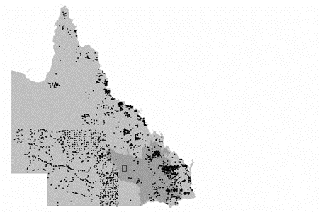
Figure 1. Location of the study area in
Queensland.
The dots in the State
map indicate previous soil sampling sites on uncultivated soils. Our study site fills a gap in the sampling
of the state. Click here to see the
study area location in more detail (study area page)
Methods
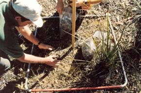
Field:
Field survey was used to estimate standing stocks
of carbon in above-ground vegetation, coarse woody debris, fine litter, and in
the soil down to a depth of 1m (Figure 3 below). These data were combined with
historical records (satellite imagery, aerial photography and landholder
interviews) to determine the disturbance histories of each site. Click here for a more detailed description
of the land cover history analysis under the Land Cover project (Land Cover Change project)
Sampling
for…
Fine litter |
||
|
|
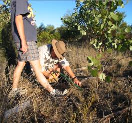
Fine
litter was collected within 1m quadrats and placed into plastic bags. Later in the lab this was sorted into
leaves, twigs and bark, and then dried in a large oven for 48 hours. Sub-samples
of each fraction were analysed for %C content, and these were used to convert
total dry weight into carbon mass. |
|
|
|
||
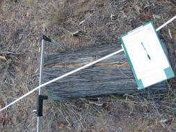
Coarse woody debris |
||
|
|
Coarse woody debris
estimates for the plot area are made using two transects within the field
plot. The transects go from the
middle point between the south west and south east corners, and run to the
north east and north west corners respectively |
|
|
|
Whenever the transect
tape crosses a piece of wood that is larger than 2cm diameter, a number of
attributes of the wood are recorded.
These are: -
diameter of the wood where the tape crosses -
tree species, if known -
how old (or rotten) the piece of wood is, in 5 broad classes (ie from
fresh wood, through to rotten / falling apart) -
the distance along the tape that the wood is found |
|
|
|
Some pieces of wood
are collected and taken back to the lab, so we can work out how dense they
are, and then how much carbon is stored in the wood. |
|
|
|
|
|
Soil carbon and bulk density sampling
|
||
|
|
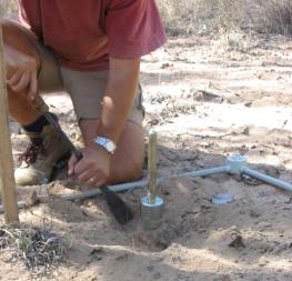
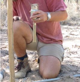
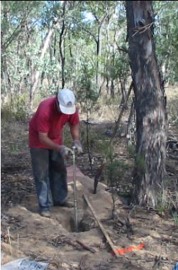
The soil is
collected at a number of points, from
the surface, and down to 1 metre depth.
The surface sample is
collected using a hand sampling tool. |
|
|
|
The soil (or sand)
is cleared from around the sample, to make getting it out easier. |
|
|
|
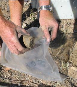
The sample is then
extracted and put into a bag |
|
|
|
||
|
|
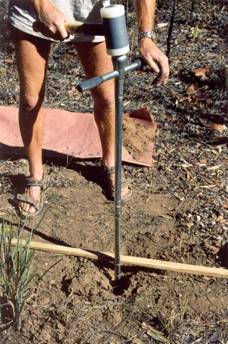
We use soil augers to
obtain samples from 10cm down to 1m below the surface. This is much easier in sandy soils than in
clays! |
|
|
|
Whacking the soil
auger, which has a special collection head on it, collects the samples. We
then pull out the auger and bag the sample. |
|
|
|
The Ph (or acidity)
of the soil is also tested at different depths. |
|

I suggest not including this figure, as none of
this data has been published yet, and it seems a bit detailed to have on a
web-page overview. What do you think? MODELLING:
A model of
terrestrial carbon dynamics was custom-designed to integrate the available
empirical information (Figure 3 & 4). Model parameters, such as the
residency times of carbon in the various pools, were estimated using model
inversion methods. This technique takes the observed carbon stocks (mean &
variance), and then searches, by genetic algorithm function minimisation, for
parameter combinations that yield modelled carbon stocks that match those
observations. Model parameters are therefore described by probability
distributions, rather than constant values, allowing variability in the
empirical observations to be propagated through the model. Once the parameters
have been estimated, the model can be re-inverted and run forward through time as
in a conventional simulation. The Injune model is being developed using the CRC
for Greenhouse Accounting’s model simulation environment COINS (Comparison
and Integration Shell).
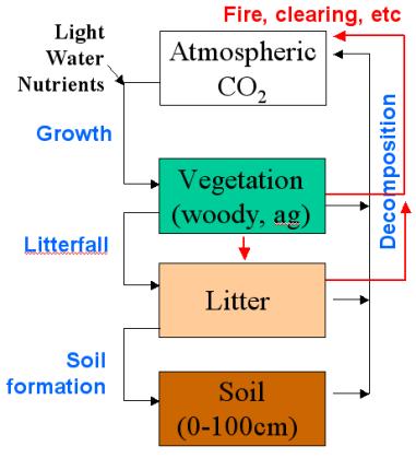
Figure
3. General model of terrestrial carbon dynamics
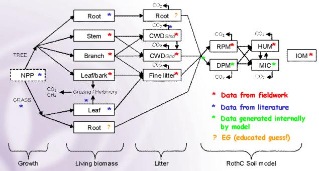
Figure 4. Detailed model of terrestrial
carbon dynamics for the Injune study.
Each month new
growth (NPP) is partitioned into grass (forage) and tree vegetative components,
and then eventually into the litter and soil. Soil dynamics are modelled using
the Rothamsted soil model (RothC), which has been calibrated for Australian
conditions. The boxes represent stores of carbon, and the arrows the fluxes.
Model behaviour / results
Two versions of the
model are being developed.
- Point (site-based) model
This version allows the
greenhouse impacts of various management activities to be assessed, at the scale of individual study sites
- Spatial analyses
This version will use the biomass relationships developed by Alex Lee, the land-cover analyses of Lucy Randall, and the landscape/topographic analyses of John Gallant/Brendan Mackey to interpolate the site model over the whole landscape. This will allow landscape-scale carbon dynamics for the Injune region to be explored, and also provides a tool for scenario development.
Figure 5a
shows the dynamics of the site model under constant environmental conditions,
using a representative parameter set derived from the inverse modelling. A
clearing event (simulated chaining combined with fire) at year 67 leads to
increased herbage growth, which declines over time as the woody vegetation
recovers. Note that the field observations (black dots) were not part of the
calibration process, and hence provide an independent validation of the model
behaviour. Figure 5b additionally includes climatic variability. Note the large
variability in herbaceous plant growth, reflecting extreme inter-annual
variability in rainfall.
|
|
|
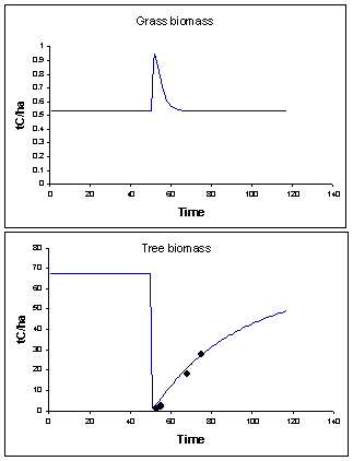
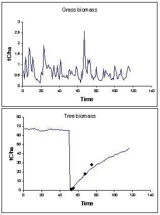
Figure
5a & 5b. Model dynamics under constant (A) and fluctuating (B)
environmental conditions
Current work
is concentrating on finalising the development of the site model, and on developing
the spatial analyses to facilitate spatial application of the model.
SUMMARY:
The analytical
methods we are developing provide a formalised methodology for linking data with
models, ensuring that all relevant empirical datasets are included in the model
calibration process. More generally, the Carbon Dynamics project provides the
means for bringing together results from a number of the Injune activities,
thus allowing the quantification of current carbon stocks and fluxes across the
entire study area, including a scenario capability for assessing the greenhouse
implications of management decisions in this important Australian vegetation
type.
Further Information
Stephen Roxburgh
CRC for Greenhouse Accounting & Ecosystem Dynamics Group
Research School of Biological Sciences
Australian National University
Canberra,
ACT 0200
Australia
Ph: +61 (02) 6125 5588
Fax: + 61 (02) 6125 5095
Email: Roxburgh@rsbs.anu.edu.au
Click here for a list of Conference presentations