
Land Cover Change
Project Overview
Introduction
The primary aim of this project is to
quantify the disturbance history at the Injune study site. The following stages are implemented to
achieve this aim:
- Land
use is assessed across the study area from existing data and checked
during field visits
- The
likely land cover history for various sites is developed through
interviews with landholders and calibration with historical records,
including air photos and satellite imagery
- Land
management data is gathered from land holders. This information can then provide insight into how different
management methods may influence the carbon dynamics of this environment
- A
generalised model of clearing practices, vegetation type and structure,
and terrain form is developed to allow assessment of change in areas not
directly visited.
1. Land use
Land use was based
on the Australian Land Use mapping procedure for catchment scale land use
mapping. Three sets of input data were used:
i
Cadastre (property
boundaries) were obtained from Queensland Department of
Natural Resources and Mining (QDNRM)
with tenure information attached.
ii
Ancillary data was
collected from 1;100,000 map series including rivers, roads, farms buildings,
dams and pumps.
iii
Landsat TM for 2000
was used to delineate cleared and remnant woody vegetation and to check
location of the ancillary data items.
The final
classification was then coded to the Australian Land Use Management version
5. The results for the study area are
shown in Table 1 below.

Table 1. Land use by area in the Injune study area
2. Land cover
history
The land cover
history layer is based on the combination of 18 Landsat satellite images from
1972-2000 (supplied by Australian Greenhouse Office and Queensland Department
of Natural Resources and Mining). Data
from the Queensland SLATS program were interpreted for land cover change, and
validated for 5 farms and by State Forests for 4 farms. Land cover history was based on raw Landsat TM data series and
historical air photos from the Queensland Archives.
Land cover from the
2000 Landsat data was interpreted first, then we worked backwards in time to
ensure integrity. The dates of clearing
were collected through farmer interviews for most of the farms where clearing
had taken place and for the State forests.
There are 13 farms
in the area, and a range of tenure arrangements exist.
v
1 farm in the area
has freehold tenure, which means that clearing of remnant vegetation, which is
not endangered, can take place under the Vegetation Management Act 1999
between. Virtually the entire farm,
Mount Owen, has been cleared in 1999.
v
10 farms are leasehold, which means that clearing of
remnant vegetation requires a permit under the Land Act 1994. On these farms substantial clearing has
taken place in Billin, Mt Owen and Derbyshire Downs and, to a lesser extent,
Hillside.
Although 18 images
were used in the compilation of the land cover history, only one of these
images was captured in the 1970s. Aerial
photos were also used to fill in the gaps along with local knowledge from the
land holders. The farmers at Mt Owen
and Hillside have only been managing since the late 80s. Figure 1 (below) shows
the final land cover history map for the study area.
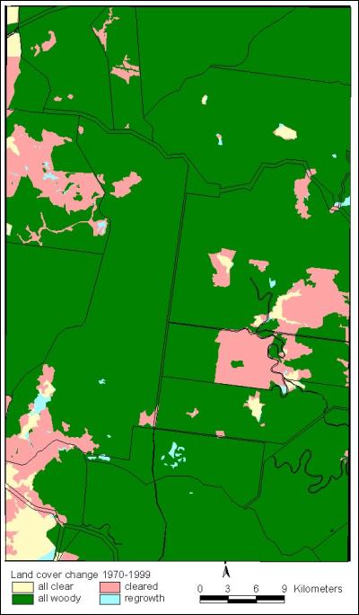
Figure 1. Land
cover history for the study area
In order to
estimate rates of clearing the data were converted into raster format and each
pixel was assigned a likely annual sequence of land cover state using a Markov
probability. Figure 2 (below) shows
that two periods of clearing occurred in the mid-70s and late 1980s reaching
nearly 20% of the study area.
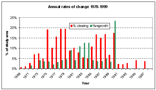
Figure 2. Clearing
rates over time, for the study area
3. Land management
history
The land management
history is based on farmers’ interview as to when, what and why clearing or
cultivation took place. There is a
whole range of land management options that the land holders use to improve
their land for cattle grazing or cropping.
These include the following, and pictures are shown below:
v
Clearing
o
Chaining
o
Blade ploughing
o
Stem injection
o
Ring-barking
o
Burning
o
Selective
harvesting (includes forestry operations)
v
Ploughing
v
Planting pastures
v
Planting crops
Chaining / pulling


Stick
rake


Stem
injection

Ring
Barking

Land management history
was also accessed from the farmer’s interviews and, to a certain extent, from
the aerial photos where chaining, ploughing and burning were readily
apparent. By far the most common
practice is chaining of these predominantly Eucalypt woodlands. Figure 3 presents the results of the land
management history assessments.
Billin has a longer
clearing history that the other farms and has moved onto offset ploughing and
planting of oats as a fodder crop.
Ring-barking has largely been superseded with stem-injection and other
chemical means in the 1960s.
These data
nonetheless have several drawbacks, particularly the short history available
for much of the study area and that prior to 1960s is unknown. This is one of the objectives of field trips
to collect more data on land management decisions.
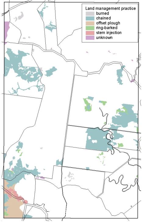
Figure 3. Land
management practises for the study area
4. Land clearing
model
There are strong
relationships between clearing practices used and the terrain characteristics
and vegetation type and structure. In
the light of the vegetation management legislation in Queensland, clearing has
taken place due to incentives such as the Brigalow development schemes in the
1960s and 70s, restrictions on leasehold land from 1994, and freehold land from
1999 and the phasing out of permits since March this year. Future clearing events will be restricted to
existing permits and the clearing of regrowth.
On top of that, how does
and did the farmer select what vegetation should be cleared and how it should
be carried out?
Current wisdom suggests
that:
v
Clearing on clay
soils will yield a greater grass biomass but may lead to problems with
regrowth.
v
Steep slopes
restrict mechanical techniques
v
Labour intensive
techniques such as ring-barking and stem-injection are limited to sparser
vegetation
v
Burning is only
carried out when there is sufficient grass biomass to maintain the burn.
This leads us to
develop a land clearing model as shown below.
Here the property tenure, vegetation cover and the terrain all influence
the management options. Because we have
digital data for all these model layers, we can investigate, and then perhaps
predict what has occurred in the past (where we don’t have historical
information) and what may happen in the future…

Further information
Dr Lucy
Randall
Landscape Management
Sciences
Bureau of Rural
Sciences
PO Box 858, Kingston
ACT 2601
AUSTRALIA
Tel:
+61(0)2-6272 4901
Fax: +61(0)2-6272
5827
Email: Lucy.Randall@brs.gov.au
Click here for a list of Conference papers on
the Publications page