
Radar Project Overview
Objectives ~ Methods ~Results ~ Further Information
Principle
Investigators
Richard Lucas (UWA / UNSW)
Natasha Cronin (UNSW)
Christian Witte (QDNRME)
Michele Patterson (UNSW)
Philip Tickle (formerly BRS & CRCGA, now GeoScience
Australia)
Alex Lee (formerly BRS, now PhD candidate, ANU)
Introduction
In 1998, a number of studies were initiated which aimed to evaluate the
use of airborne and spaceborne Synthetic Aperture Radar (SAR) for quantifying
the above ground biomass of woody vegetation in Australia. The studies were motivated by uncertainties
in the emissions of greenhouse gases associated with vegetation clearing,
regeneration and woody thickening. The studies focused on Queensland as the
State reported the highest rate of clearing in Australia in the 1990 – 1995
National Greenhouse Gas Inventory (NGGI).
These initial studies (Witte, et. al. 1998; Lucas et al.,
1999b,c,d; Lucas et al., 2000) were prompted in part by the availability of allometric equations
(Burrows et al. 1998) for woodland tree species common to
Queensland. The equations were well
suited for radar studies as they facilitated the estimation of component
(e.g.., leaf, branch and trunk) biomass as well as above ground biomass. Although historical radar data were used, a
reasonable correspondence between SAR backscatter and both above ground and
component biomass was observed at certain frequencies and polarisations. However, the relationships did not allow a
good understanding of how microwaves interacted with the different components
of the vegetation and were also complicated by the inherent relationships between
components.
An opportunity to better understand the information content of SAR data
arose with the planned NASA Jet Propulsion Laboratory (JPL) PACRIM II AIRSAR
Mission in 1999. In preparation for
this campaign, a collaboration was established between the University of New
South Wales, the Queensland Department of Natural Resources, the Queensland
Department of Primary Industries and the Bureau of Rural Sciences. An application for funding was made to the
Australian Research Council (ARC) SPIRT program to research the potential of SAR
for operational mapping of forest biomass and structural diversity in Central
Queensland. This application was
successful, and work began on organising a study site. Consequently, Christian Witte (QDNRME)
selected the Injune study area as it contained a diverse range of forest
communities at various stages of regeneration and degradation and vegetation
clearance was extensive. Although the
AIRSAR Mission was delayed for 18 months, overflights of the Injune study area
were completed on the 3rd September, 2000. In the intervening period, an intensive ground and airborne
remote sensing campaign, involving aerial photography, LiDAR and hyperspectral
sensors and supported also by the Australian Greenhouse Office and CRC for
Carbon Accounting, was planned which was implemented successfully at the time
of the AIRSAR overflights.
Since the overflights, research has focused on the scaling-up of ground
data (e.g., biomass, structural attributes) using fine spatial resolution
remote sensing data and subsequent establishment and interpretation of
empirical relationships with SAR data.
As these are complex, studies have also focused on SAR backscatter
modelling and SAR inversion for the retrieval of forest attributes. As a result of this work, new collaborations
have been forged within Australia (e.g., the Australian National University,
the University of Adelaide and the Defence Science and Technology (DSTO)) and
overseas (the University of Wales (Aberystwyth, UK), the University of Michigan
(US), the Japanese Space Exploration
Agency (JAXA; Japan) and Definiens (Germany).
As a result, X-band SAR data were acquired over the Injune study area by
DSTO in 2004 in conjunction with a field campaign to evaluate interaction at
this frequency. ENVISAT ASAR data have also been acquired to develop
interferometric methods for stand height retrieval. New SAR models for
understanding the interaction of microwaves with complex canopies have also
been developed in conjunction with the University of Michigan. The Injune study area has also been
determined as a super-site for the evaluation of the forthcoming (September,
2005) JAXA Advanced Land Observing System (ALOS) Phase Arrayed L-band SAR
(PALSAR), thereby opening opportunities for regional mapping of biomass and structure. The following pages outline in more detail,
the activities and datasets that make the Injune area at the forefront of
remote sensing research in Australia and the focus of attention overseas.
Objectives
The main objectives of this project are:
v To investigate the relationship between SAR backscatter and forest
biomass and structural attributes through a combination of empirical
relationships and forward scattering models.
v To develop new techniques for mapping forest biomass, structure
and floristics using a combination of radar and optical/hyperspectral data
based on scientific understanding of data and processes.
v To advance techniques for scaling-up
field-based measurements of biomass, structure and floristics to the landscape
using remote sensing data of varying spatial resolution.
Results
Biomass:
Based on the new and existing
allometric equations, an analysis of biomass allocation to different components
was undertaken. The decurrent forms
(e.g., Eucalyptus and Angophora species) generally allocated a greater
proportion (between 30 and 50 %) of biomass to the branches. The excurrent forms, represented largely by
Callitris species, generally allocated more than 60 % of the biomass to the
trunk. When the allometric equations
were applied to each of the SSUs, few types of woodland with more than 50 % of
biomass allocated to the branches occurred and a clear transition from SSUs
with a high proportion of biomass allocation to the branches to those with a
greater allocation to the trunks was observed (Figure 3).

Figure 3. Stand level allocation of biomass to leaf,
branch and trunk components (as a percentage of total allocation) within the 36
SSUs sampled. Plots labels contained within
a box represent woodlands selected for model simulation.
Radar analysis
Scaling-up of field-based estimates of biomass and
structural attributes to the landscape was undertaken first by establishing
empirical relationships with LIDAR data by community (as determined through
interpretation of LSP). Relationships
established subsequently between AIRSAR data and biomass suggested saturation
at average biomass levels varying from 60-75 Mg ha-1 at C-band,
73-75 Mg ha-1 at L-band and 74-113 Mg ha-1 at P-band,
with marked increases in the biomass at the level of saturation occurring at
higher incidence angles and at HV polarisations (Figure 4; Lucas et al., 2004b).

Figure 4: Relationships between LiDAR estimated above
ground biomass and SAR backscatter at different frequencies and polarisations
for one of the 10 PSU columns. Relationships differ according to incidence
angle.
Increases in SAR backscatter with
Foliage Projected Cover (FPC; estimated spatially using Landsat TM band 5 data
and the Normalised Difference Vegetation Index) were noted at all frequencies
and polarisations suggesting a proportional increase in FPC with biomass which
was supported through field observations and analysis of finer spatial
resolution remote sensing data (Cronin et al., 2004). At L- and P-band (particularly HH
polarisation), however, an increase in backscatter with FPC did not occur for
woodlands in the early stages of regrowth (e.g., areas of Brigalow) which was
attributed largely to the presence of numerous stems (and high foliage cover)
but lack of any that were sufficiently large to cause a significant return at
these lower frequencies. In contrast,
regenerating woodlands with fewer but larger stems exhibited a greater
backscatter at both L and P-band compared to bare or sparsely vegetated
areas. These observations identified
the combined use of FPC and lower frequency SAR for discriminating and mapping
regrowth (Lucas et al. 2004c).
Although empirical relationships provided options for mapping biomass
across the landscape, the nature of microwave interaction was best revealed
through parameterisation of the wave scattering model based on that of Durden et al. (1989). The backscatter coefficient simulated with the model provided a
good correspondence with actual AIRSAR backscatter at most frequencies and
polarisations (Lucas et al., 2004a).
Analysis of the scattering mechanisms also demonstrated the dominance of
volume scattering at C-band HV and increases in backscatter with foliage and
small branch biomass. At L-band and
P-band HH polarisations, trunk-ground scattering predominated and increased
with trunk biomass. At L-band HV, volume
(branch) scattering dominated and increased with large branch biomass (Figure
5). The analysis concluded that
empirical relationships between backscatter and above ground biomass were
stronger when developed within and applied to forests of similar structural
form, due partly to inherent and relatively consistent relationships existing
between the biomass of different components.
However, in mixed species forests, such relationships were less
consistent within the stand because of the diversity of structural forms and
scatter in the relationships with backscatter were observed. The use of selected channels for the
retrieval and mapping of component biomass (which could be summed to give the
total) was also identified as an option for biomass mapping.
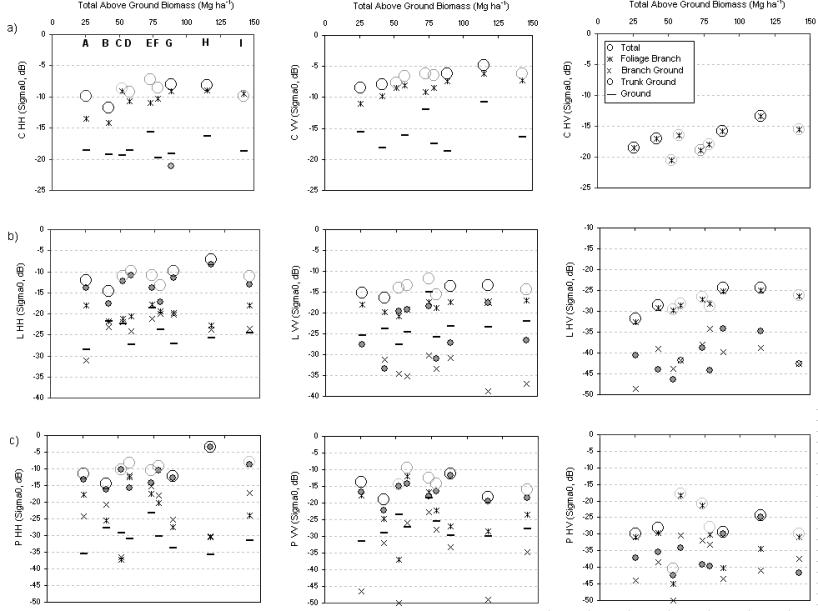
Figure. 5. Relationships between SAR backscatter at different frequencies
and polarizations and biomass and the contributions from the differing
scattering mechanisms. The total
backscatter is indicated for excurrent-dominant (dark circle or outline) and
decurrent dominant (light circle or outline), although both may occur. Plots are represented as A – I where A =
114_12 (CP-) B = 144_19 (CP-SLI) C = 142_18 (PBX) D = 23_15 (SLI) E = 58_29
(PBXSLI) F =148_16 (SLI) G = 114_4 (CP-SBA) H = 111_12 (CP-SLI) I = 81_11
(SBACP-). <species code page link>
Based on the modelling outcomes, an alternative approach of SAR
inversion procedure is being considered (Moghaddam
and Lucas, 2003b). The
inversion procedure estimates free variables using an algorithm that produces
the optimal variable following best matching between actual SAR data and a
closed-form polynomial model generated through multiple simulation. Specifically, C-band
data are used to provide estimates of crown layer characteristics (e.g., branch
densities and moisture contents) which are then used subsequently to simulate
their contribution at lower frequencies, thereby allowing the backscatter to be
adjusted such that only stem and ground effects remain. A closed-form model with fewer variables can
then be generated for inversion of the lower vegetation layer. L and P band data are used subsequently to
estimate stem and ground variables (e.g., stem moisture content). Based on the resulting data layers derived
through the modelling process, and by applying known ratios of wet to dry
biomass for key species, spatial estimates of total and component biomass were
generated for the Injune study area.
The approach shows considerable promise for quantifying biomass and
structure across the study area and may potentially be applied using data
acquired from current and future spaceborne sensors.
|
|
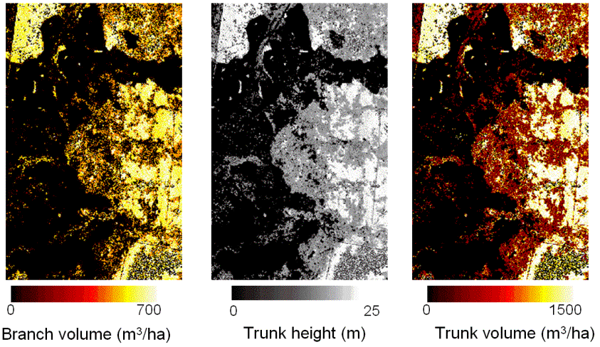
Figure
5. Estimates of biomass and structural
attributes generated from SAR backscatter model inversion.
A limitation of many forward scattering models is that
they have generally been designed for a forests containing a single species of
the same growth form (e.g., a plantation).
Recent research (Liang et
al., 2004) has focused on the modification of the MIMICS
model such that the diversity of layers and stand structures in mixed species
forests can better represented and modelled.
The resulting multi-MIMICS model has therefore been developed in light
of the conclusions reached by Lucas et al. (2004a) and parameterised using the Injune
field data from a wider range of sites.
Multi-MIMICS therefore has direct application to the forests at Injune
and represents a major advance in the development of inversion algorithms.
ALOS PALSAR and ENVISAT ASAR
As a PI for ALOS PALSAR, Injune is now recognised as a
supersite for the collection of data. Specifically,
all modes of data will be acquired over the site, including fully polarimetric
data. Furthermore, ENVISAT ASAR data
have been acquired. The extensive
ground and fine spatial resolution remote sensing datasets and the
understanding gained from the present study provides one of the best
opportunities for understanding the benefits of using the spaceborne SAR
sensors, either singularly, in combination, or with optical data.
Further information
Institute
of Geography and Earth Sciences,
The
University of Wales, Aberystwyth,
Llandinam
Tower,
Penglais
Campus,
Aberystwyth,
Ceredigion,
SY23
3DB.
Tel:
00 11 44 1970 622612.
Fax:
00 11 44 1970 622659
Email:
rml@aber.ac.uk
Journal Papers
For a list of
journal publications, go to the Publications page.
Conference
articles
For a list of
journal publications, go to the Publications page.