
Queensland MISR & Lidar
Projects Overview
Principle Investigators
Christian Witte (QDNRME)
John Armston (QDNRME)
Trevor Moffiet (University of Newcastle)
Introduction
The Queensland Dept of Natural
Resources, Mines and Energy is coordinating a series of projects that seek to
enhance the utilisation of the data,
research and knowledge gained from the Injune study site.
At present there are two main
projects underway or substantially completed.
These are as follows, and are described briefly below:
- Analysis of
multi-angle imaging spectro-radiometer (MISR) measurements in the Queensland
southern Brigalow Belt
- Statistical
Methods in Vegetation Remote Sensing Applications
These projects will enhance
ongoing Queensland government initiatives such as the Statewide Landcover and Trees
Study (SLATS). See here for more
information http://www.nrme.qld.gov.au/slats/
1. MISR analysis
Introduction
This
research is being undertaken as an Honours thesis at the University of
Queensland, in conjunction with the Natural Resource Sciences section of QDNRME. The objectives of the honours
thesis are as follows:
1. Develop a methodology for characterising MISR Local Mode sub-pixel vegetation structure with field and LIDAR data;
a. Derive estimates of foliage projective cover (FPC), predominant height and sub-pixel surface heterogeneity using discrete scanning LiDAR;
b. Assess the accuracy of these estimates using coincident field data.
2. Characterise the spectral directional reflectance of the land surface in the Queensland Southern Brigalow Belt Biogeographic Region;
a. Correct MISR Local Mode Data for atmospheric effects;
b. Invert linear kernel-driven and non-linear multiplicative BRDF models against these data and assess the inversion accuracy;
c. Assess the spatial and temporal variation in the BRDF model variables.
3. Assess the statistical relationship between spectral directional reflectance in terms of foliage projective cover (FPC), predominant height and sub-pixel surface heterogeneity in the Queensland Southern Brigalow Belt Biogeographic Region.
Abstract
Many theoretical and
applied studies have demonstrated that the anisotropic reflectance of the land
surface can be used to characterise the structural and optical properties of
vegetation. The Multi-angle Imaging SpectroRadiometer (MISR) has the potential
to characterise vegetation structure and consequently improve the operational
monitoring of vegetation structure in Queensland. The aim of this pilot
investigation was to produce a quantitative comparison of MISR multiple view
angle (MVA) measurements and vegetation structure for the Southern Brigalow
Belt (SBB) Biogeographic Region.
Airborne LIDAR data was
used to estimate foliage projective cover (FPC) at the spatial resolution of MISR
and was validated using coincident field data. Coefficients describing the
shape of the bidirectional reflectance distribution function (BRDF) were
derived by inversion of the linear Ross-Thick Li-Sparse Reciprocal and the
non-linear Rahman-Pinty-Verstraete (RPV) models against a time series of MISR
“Local Mode” surface bidirectional reflectance factor (BRF) data. Comparison of
model inversion accuracy and correlation with FPC revealed the RPV model
coefficients were related to spatial and temporal variations in vegetation
structure in the Queensland SBB and are consistent with published findings. The
application of these data to the operational monitoring of woody and herbaceous
vegetation cover and change in Queensland is currently undergoing further quantitative
evaluation.

MISR Example Red and NIR surface BRF images for the
27/09/2003 acquisition over the study site. The images are multi-angular red
(60º forward), green (nadir) and blue (60º backward) composites. A Landsat-5 TM
image (18/08/2003) of the study site (Bands 5-4-2 RGB false colour composite)
is also shown for comparison.
Further Information
John
D. Armston
Natural
Resource Sciences
Queensland
Department of Natural Resources and Mines
80
Meiers Road, Indooroopilly,
Queensland,
Australia,
4068
Phone
+61 7 3896 9696
Fax +61 7 3896 9843
Email:
john.armston@nrm.qld.gov.au
Click here for a list of publications on the publications page
2.
Statistical Methods in Vegetation Remote Sensing Applications
Introduction
This
research is being undertaken as a PhD thesis at the University of Newcastle, as
part of an ARC Linkage project in conjunction with QDNRME. This
research is specifically directed towards development of statistical methods
required for collection, modelling and analysis of remote sensing data in
vegetation applications. In particular,
the applications involve airborne Lidar data combined with other data types
used to describe characteristics of forests and woodlands such as tree species,
stand history and vertical distribution of foliage, and hence biodiversity and
biomass. The primary statistical
methods of interest are associated with data exploration, calibration of Lidar
measurements with field measurements, and integration of data of different
types (e.g. Lidar and CASI (Compact Airborne Spectrographic Imager)) obtained
at different spatial scales.
Summary of current work
A paper has been completed on
exploration of Lidar data from the Injune site. The main objective was to
determine if the intensity returns of Lidar signals could be used to improve
the calibration relationship between foliage projected cover (FPC) determined
by Lidar and foliage projective cover (FPC) green leaf component determined by
measurements in the field.
The investigation indicated
that individual intensity return is dependent on the portion of pulse footprint
available for reflection and does not carry any unique information on the
foliage surface such as leaf or branch. The average and standard deviation of
return signal intensity for a survey site may carry information on forest
structure but these statistics are only useful for comparison if the incident
intensity is relatively constant and equal for sites being compared. Site based indices that may be suitable for
comparing forest structure were found to be:
v
the proportion of vegetation first returns
that are single amplitude returns and;
v
the proportion of vegetation first returns
that have a corresponding second return from the ground (termed vegetation
permeability).
These indices are also
useful to explain how the average and standard deviation of return intensity
are related to forest structure (given a constant incident intensity).
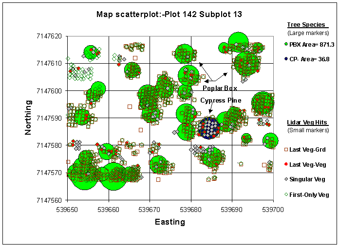
Different species appear to have different lidar return responses, with Callitris species tending to have more single return strikes.
Calibration of lidar FPC with field FPC is typically done using simple
linear regression based on the ordinary least squares (OLS) method of fitting
the regression line. However, while the estimate of the calibration slope is a
reasonable approximation in this case, proper calibration requires
consideration of the errors contained in each variable. Both variables are not
direct measures of foliage cover but are only estimates of true cover. In
particular, for data that are proportions, proper consideration needs to be
given to the distributions of the errors to enable appropriate confidence
limits to be determined for the regression slope and for calibration
predictions of true cover.
In current
investigations, the error distribution of the transect method for measurement
of FPC in the field has been modeled and an errors-in-variables model is being
developed specifically for the calibration of two proportions obtained by
different measurement methods. The
errors in variables model for proportions appears to be unique and should have
application beyond that of calibration of Lidar and field based FPC.

Callitris (left) and Poplar box (right)
tree species are quite different in form and foliage, and lidar is seemingly
able to characterise this difference based on structural properties.
Further Information
Trevor. Moffiet
University of Newcastle,
School of Maths and Physical Sciences,
University Drv.,
Callaghan
N.S.W., 2308
Email: Trevor.Moffiet@newcastle.edu.au
Click here for a list of publications on the publications page